


Unusual water level variations in the St. Lawrence associated with Hurricane Dorian
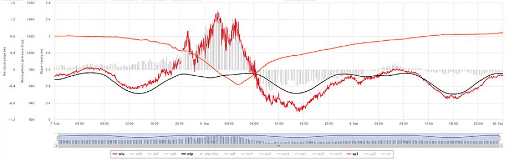
Hurricane Dorian, which became a post-tropical storm over Quebec on September 7 and 8, 2019, disturbed the normal tidal cycle, causing extraordinary water level variations. During the storm’s passage, numerous storm surge warnings were issued for the St. Lawrence River and the Gulf of St. Lawrence. In Quebec, the Magdalen Islands were particularly affected. The steep drop in atmospheric pressure from 1,020 to 960 mbar in the space of a few hours (Figure 1 – orange line) in this area of the Gulf and the rapid passage of the low pressure system produced a suction effect, which caused the water level to rise to 2.6 m. This is 20 cm higher than the extreme value recorded on December 22, 2008. The storm surge created by the low-pressure system and the associated winds raised the water level by more than 1.6 m over the predicted tide at the Cap-aux-Meules station (Figure 1). Positive surges were also observed at the Rivière-au-Renard (46 cm), Sept-Îles (19 cm), Rimouski (26 cm), Quebec City (45 cm) and Portneuf (51 cm) stations. Fortunately, these surges did not coincide with the largest tides for September and therefore coastal flooding was limited.
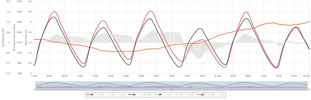
The low-pressure system subsequently moved toward the Atlantic Ocean. The area of low pressure near the Cabot Strait produced a suction effect, holding back water from the Atlantic Ocean and thereby causing a decrease in the amplitude of the tidal wave in the Gulf of St. Lawrence and the St. Lawrence River. The effect on the next high tide was spectacular, with water levels much lower than the predicted tidal values on September 8. This effect was observed as far upriver as Trois-Rivières, more than 1,000 km from the Magdalen Islands. Increasing negative surge values were recorded in an upstream direction in the St. Lawrence, as observed at the Cap-aux-Meules (-43 cm), Sept-Îles (-33 cm), Rimouski (-52 cm), Quebec City (-118 cm – see Figure 2), Portneuf (-116 cm) and Trois-Rivières (-15 cm) stations. A number of riverside residents in the area between Rimouski and Portneuf had the impression that the high tide had disappeared. The Canadian Coast Guard Marine Communications and Traffic Services even had to ask a ship to drop anchor because of insufficient clearance below the keel. In the September 18 edition of the daily Le Soleil, reporter Jean-François Cliche wrote that in the Trois-Pistoles region “the predicted high tide simply did not occur.” The ferry to Ile aux Basques remained grounded at high tide; and the ferry from Les Escoumins had to turn back because there wasn’t enough water at the Trois-Pistoles wharf.
A low-pressure system of this magnitude (960 mbar) in the Gulf of St. Lawrence is a fairly rare occurrence. Surface water warming in the Atlantic may lead to an increase in the frequency of such systems. While mariners and riverside residents are still shaking their heads, the phenomena associated with Hurricane Dorian have helped researchers learn more about the ocean–atmosphere links.
Denis Lefaivre and Bernard Tessier
Science

Photo credit : Fisheries and Oceans Canada, M. Therrien
Click here to see an enlarged version
Figure 1. Observations at the Cap-aux-Meules station. Graph showing the steep drop in atmospheric pressure, from 1,020 to 960 mbar within a few hours in the Magdalen Islands region and the rapid passage of the low-pressure system, which produced a suction effect causing the water level to rise to 2.6 m.
Click here to see an enlarged version
Figure 2. Observations at the Old Quebec station. Graph showing that the area of low pressure near the Cabot Strait produced a suction effect, holding back water from the Atlantic Ocean and thereby causing a decrese in the amplitude of the tide in the Gulf of St. Lawrence and the St. Lawrence River. The effect on the next high tide was spectacular, with water levels lower than the predicted tide values (negative surge) on September 8. A negative surge value of -118 cm was recorded at Quebec City.
Legend :
Observed water level – red line
Predicted level – black line
Atmospheric pressure – orange line
Black vertical lines – difference between the observed water level and the predicted tide


