
Follow Ocean Forecasting for the St. Lawrence Online!
Ocean forecasting for the St. Lawrence is now available online on the St. Lawrence Global Observatory (SLGO) website. Prepared by a team from Fisheries and Oceans Canada's Maurice Lamontagne Institute, these forecasts provide specific and essential information used by the marine transportation industry, departments and agencies, and organizations, managers and stakeholders carrying out marine-related activities.
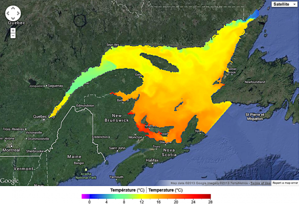
48-hour current, ice and surface temperature forecasts for the St. Lawrence
These forecasts are created through a three-dimensional ocean model coupled with the Meteorological Service of Canada's atmospheric forecast model. Both the ocean and atmospheric models are used every day to produce 48-hour forecasts. The ocean model calculates various oceanographic parameters, including currents, water levels, temperature and salinity, as well as ice drift, concentration and thickness.
48-hour surface current forecasts for the St. Lawrence Estuary
These forecasts are produced using a three-dimensional digital model that synthesizes tidal currents in the St. Lawrence River between Trois-Rivières and Cap de Bon-Désir. These forecasts do not include the effect from winds or the spring flooding period. The model was validated in calm weather conditions with a series of statistically significant measurements from drifting buoys. Although tides explain a high percentage of current energy in this area, forecasts must be used with caution in intense or extreme winds as well as during spring flooding.
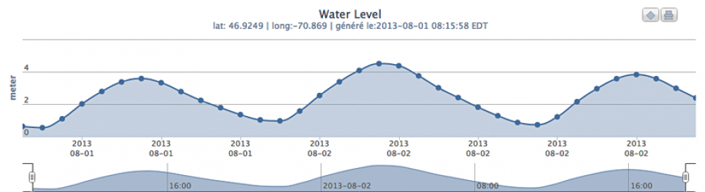
30-daywater level forecasts
Water level forecasts for the St. Lawrence River between Montreal and Saint-Joseph-de-la-Rive are listed in real time and produced using a one-dimensional model that takes into account outflows from Lake Ontario, the Ottawa River watershed and other St. Lawrence River tributaries. This model takes into consideration tides and atmospheric influence over 48 hours to predict waves and storms. The model was validated using observations from the Canadian Hydrographic Service's tide gauge network. Instructions on the SLGO's website describe how to get water level forecasts for up to 30 days at a given location.
Ocean forecasting for the St. Lawrence is now available online in the Environment section of the St. Lawrence Global Observatory website.
Want to know more about operational oceanography?
Forecasts: helping us follow the current
Feature article from DFO Science, September 15, 2011
Denis Lefaivre
Science